舊天輪-霧峰高壓線 Old Tianlun-Wufeng High Voltage Line
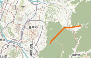
民國 69 / 1980 年台電將天輪-霧峰高壓線中段 18.2 公里長的部份移至大甲溪南邊。 本文來探討其台中市和平、 東勢、 新社、 太平區各鐵塔遺址精確位置, 供大家探索這些半山腰原來難猜怎麼會出現之神秘平台。
In 1980 TaiPower relocated the middle 18.2 km. section of Tianlun-Wufeng High Voltage Line to the south of Dajia River. The goal of this paper is to precisely locate the original pylon positions through Taichung City Heping, Dongshi, Xinshe, Taiping Districts, so readers can explore these otherwise unexplainable flat spots in the mountains.
西 W, 舊線 old line 大甲溪以北, 東 E
西 W, 今線 new line 大甲溪以南, 東 E
所有今線 All current lines: Open Infrastructure Map.
翻開「臺灣經建版地形圖」 , 無論第一版 (1989 年), 第二版 (1993 年), 第三版 (2001 年), 位於台中市東勢區慶福里燥坑為例, 均見到兩條高壓線:
Digging through topographic maps (1989 through 2001) of Zaokeng, Dongshi District, Taichung City, Taiwan, we see two high-voltage power lines:
![[Image: 2001年臺灣經建版地形圖 map tile]](images/zaokeng_TM25K_2001.jpg)
北線為今天之 The northern line is today's 天輪-翁子線 Tianlun - Wengzi line. (注意: 到翁子, 而非霧峰。) (Note: to Wengzi, not Wufeng.)
而南線為地圖出版當時卻已拆之 The southern line is the 舊天輪-霧峰高壓線段 old Tianlun-Wufeng High Voltage Line section, oddly still on the maps though having already been dismantled at the time of their printing.
1977/11/01 像片基本圖 比例尺 1/5000 天冷 9521-2-035 版次 1:
為了方便手機觀看, 上邊是西。 For the convenience of cellphone viewing, west is up.
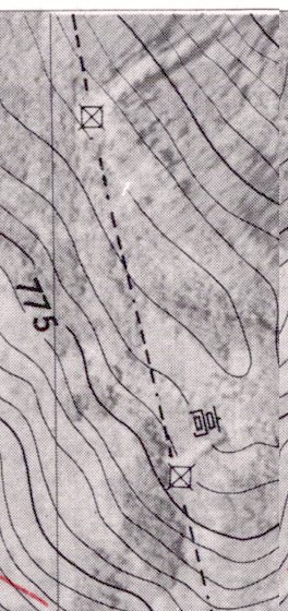
因有標出「☒」鐵塔, 逐塔址輕而易取。 惟如 9521-2-026 逐塔僅標點, 而 9521-2-041, 042, 051 僅標線, 未標點。 本圖下 (東) 塔為 3609 地號者, 上(西) 者則屬部份無專屬地號塔者, 暫稱 W. We temporarily give a tower without its own parcel number the name W.
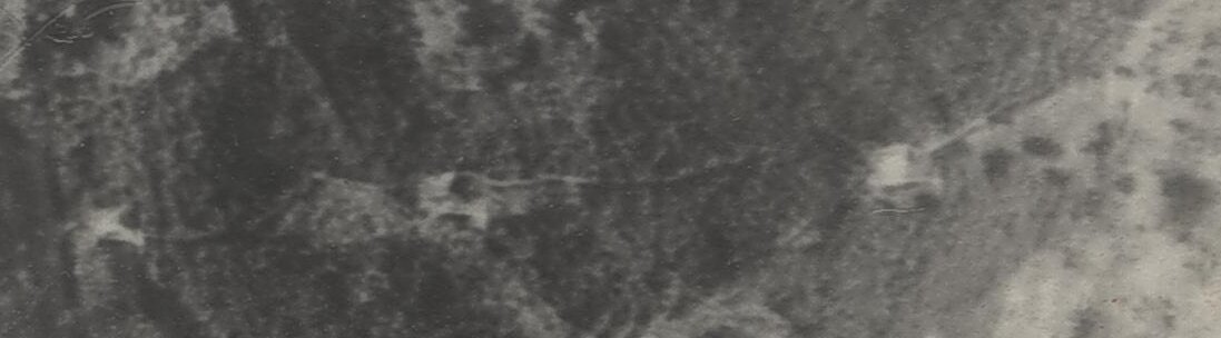
民國 63 / 1974 年 2 月 01 日拍攝 63-004-0164 號圖。 3550 地號塔, 勉強能見到塔體, 往右「>」, we can barely make out the tower structure, pointing right (>):
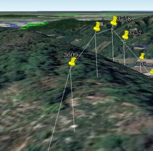
同圖資, 東往西: 3609, W, 3758, 3757 地號塔: (上邊是西。 West is up.)
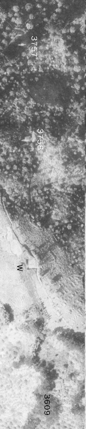
比較民國 48 / 1959 年 9 月 17 日拍攝, 06-7377E-001 TFB No. 6 圖: 3757, 3758, W 塔。
翻開上述 3609, (W,) 3758, 3757 之地籍圖,(上邊是西。 West is up.)
W 不見, 因無地籍。 W is gone, because it didn't have its own parcel number.
其他易認之地籍塊串: Additional easy to spot parcel chains: 和平區南勢段、 東勢區大茅埔段 (即上圖)、 新社區水底寮段上水底寮小段 (惟到了太平區, 正如像片基本圖無 「☒」, 地籍也難找!)
民國 58 /1969 年, 比例尺 1/1200 臺中縣 (林班解除地測量) 地籍原圖 大茅埔段圖五五幅內第 34 之 3 號圖 3557 地號:
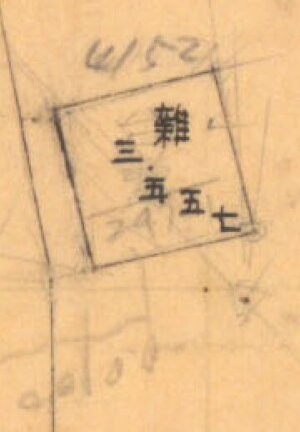
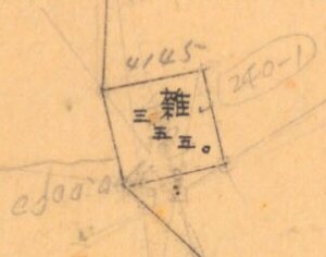
圖中見到地號 3557 + 595 = 另一種地號 4152. 附近均如此。 還有 247-1 地號。 (247 為今 3513.) 面積 0.0100 公頃, 即 100 平方公尺。 地目: 「雜」。 「台電」二字明確。 又 3550 圖中 240-1 地號。 (240 為今 3551.) 面積 0.0090 公頃, 即 90 平方 公尺… (可見, 編訂號碼 3550 地號在 1951 年建塔之後。 而編訂 "240" 地號在 1951 年建塔之前, (仍屬當時的東勢事業區, 第 32 林班, 年代。)) 現場撥開雜草, 發現一座 5.0 乘 5.0 公尺寬, 深度不詳, 的水泥地下水池頂。 另參考 3609, 3758, 3757, 3747…
比較舊線逐塔位土地登記, 與一般附近今塔, 大致如:
Comparing land registration of our old tower parcels line with current nearby ones, one observes mostly:
| 舊塔位今登記 | 附近今塔 | |
|---|---|---|
| 權利人類別 | 國有 | 本國私法人 |
| 所有權人 | 中華民國 | (台電) |
| 管理者名稱 | 財政部國有財產署 | (台電) |
| 使用地類別 | (原地目「雜」,今各種) | 特定目的事業用地 |
| 國土利用現況調查 | (各類) | 公用設備 |
| 登記日期 | 民國年月日(空格) | 民國xxx年xx月xx日 |
| 面積 | [x]x0 平方公尺(粗)※ | [x]xx 平方公尺(細) |
※ 60, 70, 80 … 170 平方公尺。
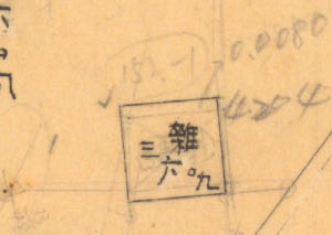
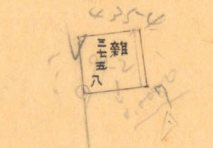
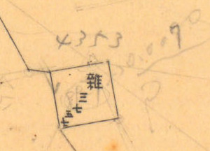
從東往西, 我們來看大茅埔段逐筆面積(平方公尺):
Going east to west, let's have a quick look at each Damaopu Section parcels' sizes (m2):
3350: 90; 3342: 80; 3454: 80; 3444: 80; 3557: 100; 3550: 90; 3609: 80; 3758: 70; 3757: 70; 3747: 80; 5283: 80; 5279: 60; 5162: 100; 5182: 180;
| 地號 | 塔號 |
|---|---|
| 3350 | 14 |
| 5182 | 28 |
蠻吻合我的數量! 待某天有人拜訪霧峰辦公室, 把整體理清。
Fits my estimates! The whole story will have to wait for somebody to visit their Wufeng offices to get all the details.
(161kV 或 154 kV?)
新建天輪-霧峰(1952)、 輸電專輯 - 台灣電力系統東西聯絡線的推手蔡瑞唐: 「民國 40 [1951] 年台電成立天峰線工程處(天輪至霧峰), 同年 1 月蔡瑞唐兼任該處主任, 次年 8 月這條線路 (154kV) 竣工。」 同句又見於 2016 年 1 月 《源》 雜誌 65 頁。
「開始建立天冷至霧峰變電所間輸電線路, 於1952年8月完成。 全線於1953年完工。」
「…舊天輪~霧峰線, 該線路業於 69 年間配合輸電線路改建而拆除。」:
1951 - 1980 (民國 40 - 69) 年 = 29 年
我曾拜訪(今)天輪-霧峰線 021 號塔, 牌底寫 「中華民國 69 年 4 月建設」。 日期吻合。
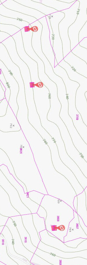
"?" 者為已地籍重測者, 我未翻老地籍圖找者。 到了太平, 我只是用猜, 是不是該線過山的嶺線, 可能本來有塔於此者。
逐塔採高度 40 公尺, 依據:
雖是「塔」, 但我仍用「桿」簡單製圖。 塔又可能掛如 3 × 2 = 6 線。
如為何天輪-霧峰線拆掉、 南移, 等等超出本文範圍。
E.g., why did Taipower move the line to the south? That's beyond the scope of this article.
當然如太平區逐塔原來在哪裡, 此待有人拜訪台灣電力公司台中供電區營運處(霧峰), 慢慢拼錯。
Of course e.g., the Taiping District tower locations, where were they exactly? This will have to wait for someone to visit TaiPower (high voltage) office in Wufeng to slowly figure out.
當然這些山上的平台是夢想中立水塔之處, 如農民發現…
Of course these flat areas in the mountains make great platforms for water tanks, etc. as farmers have discovered.
歷史圖源: 中央研究院人社中心地圖與遙測影像數位典藏計畫。
Historical map source: The Map and Remote Sensing Imagery Digital Archive Project, Research Center for Humanities and Social Science, Academia Sinica.
積丹尼 Dan JacobsonLast modified: 2024-01-14 05:33:42 UTC