![[Sketch: US/Canada boundary monument]](images/monument_sketch.jpg)
In 1994, I along with Yingyu Deng, went to explore the border between the U.S. and Canada (49th parallel) finding boundary monuments. We went from the Lake of the Woods to the Continental Divide.
Whereas some folks think geocaching or finding confluences is neat, I think it's neat to find political borders. So do lots of other folks, otherwise, the US's Four Corners (AZ,NM,CO,UT) wouldn't be popular... Indeed, the thrill must be most high on "demilitarized zone" style borders, with landmines, etc. In 1994, we explored the border section connecting: US: Minnesota, North Dakota, Montana; Canada: Manitoba, Saskatchewan, Alberta. (MN, ND, MT, MB, SK, AT). Funny, why do I think these man made imaginary lines are neat? I don't know. Perhaps it is bad. Perhaps I'm a real borderline case [hilk, hilk]
I had prepared maps by the International Boundary Commission (IBC). On the IBC website one can get the exact coordinates for all monuments in this story.
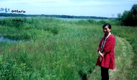
I almost got to the northernmost point in the 48 states, when I went to Angle Inlet, MN (community and water feature), but I only got as far as Sec. 19 R34W T168N (highest township number in the USA (Alaska too?), without a boat (nor boat skills) to get to the actual final ON-MB-MN tri point, 5 km. to the WNW of where we got to: photo, 95d 05' W 49d 21'N looking NE from approximate area of shore monument[?] '8' (which I couldn't find), across the water to the Canadian side. As it was summer, I couldn't take any of the 'winter roads' on the topo map [whose links shifted, so I removed them], to the goal. Angle Inlet is an arm of the Lake of the Woods. The tri-point is the most northwesterly point of the Lake of the Woods, as interpreted from British-US treaties. Reference: the Canadian book "Men and Meridians".
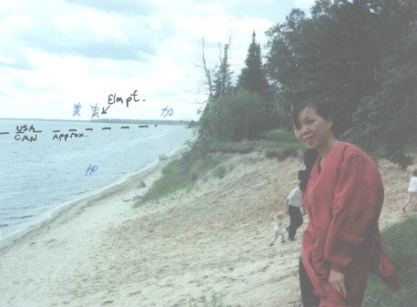
Eastern most extreme of the 49th parallel boundary, its first landfall headed west: photo 95d 15' W 49d 00' N on Lake of the Woods, looking west along boundary, drawn approximately on photo. Taken standing at beach at South Shore Heights resort community, Buffalo Point Indian Reserve, Manitoba. One doesn't have to be an Indian to lease cabins for 49 years, etc. The border slices Elm point shown in distance 2 1/2 km due west of my camera. (Does it all matter?)
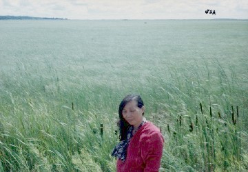
This photo probably was shot at roadside 1 mile NE of Elm Point where main E-W access road is nearest to the (impassable unless perhaps in winter) swamp to the south. We are looking south across swamp. The clump of trees at right is probably Elm Point and thus Minnesota. We are standing in Buffalo Point Indian Reserve (I.R. 36) 49d 01'N, too bad I didn't have today's GPS, I could then give a very accurate longitude, rather than the '4 mi. E. of Hy. 12' I had noted on the back of the photo at the time.
Monument 903. We got here from the Canadian side.
Tire tracks into USA, and rusted "PENALTY" (if you don't remember to report to US Customs) sign. Photo looking south into USA; her hands and stretched scarf are aligned on the border. She is standing in right tire track. Just W of Joe River 49d 00'N 97d 09'W elev. 238 m; 1/2 way through Sec. 5 T1N R3E Emerson area MB, Sec 29 T164N R50W Kittson Co. MN. ~1/5 mile W of monument 836.
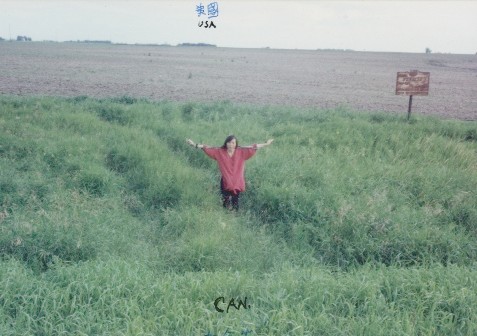
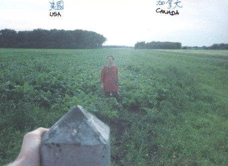
Monument 835, 3 km E of Emerson, MB. Photo looking W: border goes through monument and Ms. Deng. Obviously this Kittson Co. MN vegetable field extends a few meters into Canada. 97d 10' W, 49d N. Sec 6 T1N R3E Manitoba, Sec 30 T164N R50W Minnesota. Elev. 242 m.
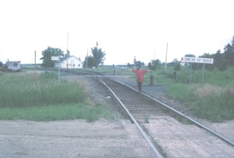
Canadian Pacific Railroad tracks enter Noyes, MN, USA. Sign: "End of CP Track." Photo looking south, 97d 12' W, 49d N. elev. 239 m. Sec 25 R51W T164N, MN. Her arms are stretched along the border line.
The MN ND MB tri-piont involved mud or something. Never made it too close. Besides, it's near the Interstate Highway 29 border crossing, left out also as too mundane.
There are several stretches of the border where a road runs atop the border [but no need of a photo.]
A shame I didn't visit Boundary Lake, with its islands divided by international borders. (Also see https://www.worldislandinfo.com/.) Must be due to getting stuck in the mud in Turtle Mountain Provincial Park, Manitoba. Non-driver Yingyu came up with the cool headed solution of driving on the road cut V incline surface grass to get back out.
Manitoba, Saskatchewan, North Dakota border tri-point.
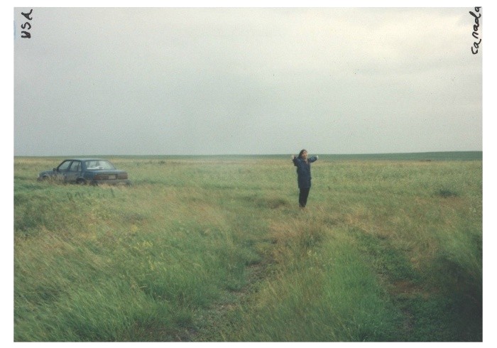
There are plenty of places where one could just ride a car across the border with nobody to stop you, e.g., here, 300 meters W of the Manitoba, Saskatchewan, North Dakota border tri-point. Photo looking W. Ms. Deng has arms aligned along actual border. 101d 22'W 49d N; Car has turned onto dirt road separating Sec 30 R82W and Sec 25 R83W, T164N Bottineau Co. ND; ...Sask. elev. ~470 m.
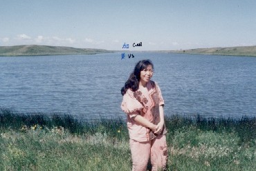
Upper Des Lacs Lake. Photo on road halfway across lake, looking NW along lake axis. From a topo map [whose link broke], one could see the main river is behind her, and the left side is just a dead end flooded gully. Saskatchewan begins at 1.2 km into the background on the right shore, and a little further into the background as one moves left. We are standing in Upper Des Lacs National Wildlife Refuge, Burke Co. N.Dak. Sec 34 T164N R89W. The lake's water flows SE bound. Elev. 555 m. 48d 59.5'N 102d 12'W
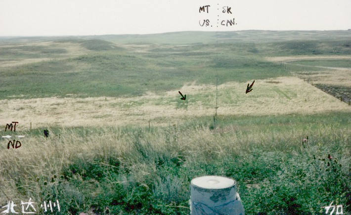
Saskatchewan, North Dakota, Montana border tri-point. To get here, at least in 1994, one approaches from the north, parks at an oil well, and walks the remaining 400 m.
Booster shot. We step back to a supplemental survey disk, as opposed to the standard pyramid topped marker. This disk, on the ND SK border, and within meters of me, the photographer, looking due west here, is needed due to monument 583, the ND-MT-SK tripoint, being located in a depressed area.
I've tried to point out 583's general location with the crude arrows, but one can't see it with certainty. One notices the unused (for 100+ years) road allowance on the Canadian side, being a swath 20[?] meters wide all the way to the horizon. This, and why the "border fence" must be slightly on the USA side, are discussed below. One wonders what the black object looking like a bird sitting atop a fence pole in the 583 area is. It is not the Customs sign. That sign one can clearly see is now at the left 7/8 of the photo, close to where I've etched the MT ND boundary [white dashes, estimated from fence inside MT on previous photo] well within the USA, and within ND as shown better by the previous photo.
Apparently the layer of dust deposited in the car from visiting all these important places wasn't part of the rent-o-car agreement, causing them to hit my credit card for an extra $25 "cleaning fee". On my permanent record I am now surely Dan "cleaning fee" Jacobson.
One might want to get a photo of the MT SK AB tri-point, but it takes more effort as one moves westward.... indeed once one hits the Rocky Mountains, access to an arbitrary point on the border would be a real chore, especially if not all crew members share your dweeb interest.
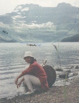
If the reader were to magnify this photo of Cameron Lake, you would discover the blue line I've sketched delineating how the border cuts this lake, 3 km southwards. Where the line reaches the ridge crest is where the border crosses the continental divide. At that point would be monument 272, 114 d 04' W 49d N. Indeed, the British Columbia, Alberta, Montana tri-point. Looking SSW, Waterton Lakes National Park (Waterton Glacier International Peace Park), Alberta. Water level 1660 m.
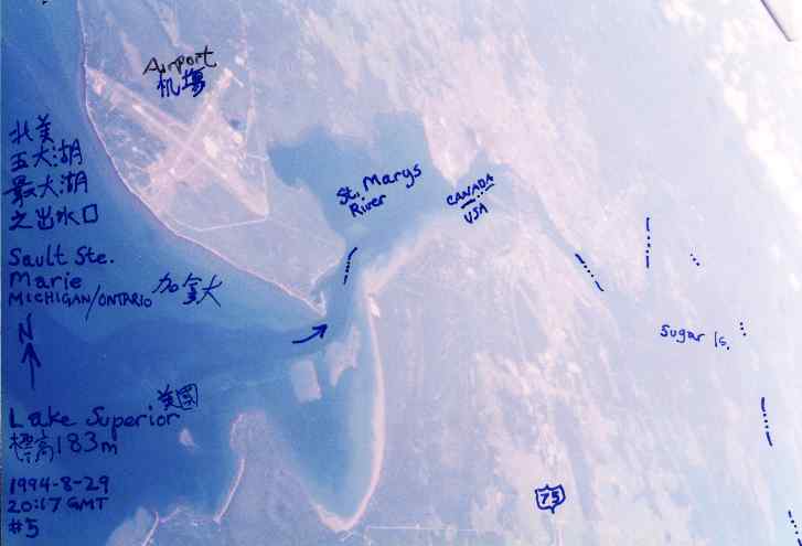
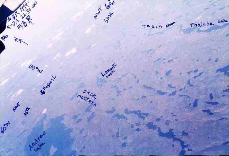
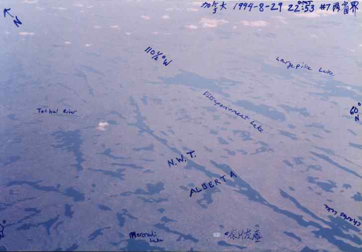
Some extra aerial border etc. images from a Detroit to Tokyo flight:
Sault Ste. Marie Ontario / Michigan. The outlet of Lake Superior.
NWT/Alta border. (Chinese at bottom says "looks like a spot of dust" :-( )
Indeed, keep on flying and you'll reach Diaoyutai 200 km NE of Taiwan.
I knew where I was on the flight using an old fashioned maps and clock.
By the way, we also visited the North Dakota / South Dakota border.
Every night we went camping. My trip notes, which are written on the backs of my photos, indicate that I took many an international piss, however managed to neglect camping on top of the border. Perhaps it was because often small towns in this part of the prairies offer free camping sites, even with showers, etc.
Ms. Deng had visas for both countries and a Taiwan passport. I carried a US passport. Only at the Port of Raymond MT, did they insist on even checking if I was carrying counterfeit money. I passed them the keys and let them get their checking jollies digging through my Dan "cleaning fee" Jacobson car while took a relaxo in their office.
They finally turned up a half empty bottle of cooking wine, which I told them was all theirs if they let me go so I could get to the campground before sunset.
For this trip I had carried a reply to my inquiry letter to the IBC, so I could show I was 'on a mission' in case stopped somewhere away from official customs ports of entry---but I never had occasion to use it. Looking at my records, it appears I also wrote a letter to the US Border Patrol warning them of my great travel plans... hmmm, I suppose there was no need to tell them... must have been a side effect of me thinking I'm such a big deal.
Don't go walking up to border check posts and expect to get across, unless I suppose you are a citizen of that country. This time [1994] I used a rent-a-car, but I remember back in 1978 or 9 when I was about 18 years old, I hitchhiked through Canada to Alaska. First one must enter Canada: I walked up to the Roseau MN crossing after a car had dropped me 1/4 mile previous. I got turned away by Canadian Customs for having 'no visible means of support' etc. Luckily got through in a crowded pickup later at Warroad. Got all the way to Alaska, and when loping back via the Taylor Highway, the northernmost road crossing between US and Canada, I again got dropped off just a few km from the Canadian (Yukon) border and decided to walk... well, after the thorough search, I was informed that I was not getting across, and if I snuck across, he'd shoot me. I informed him that summer was almost over, and that his chump* country happened to be in the way from me getting back home to Chicago. Anyways I tried to get back out via the Alaska Highway main route, but it seems Mr. Dickhead had informed them via radio as I got plucked out of the car that was carrying me and ended up with no other option than to return to 'Tok' Junction and call Mom to wire the $ for an air ticket Anchorage to Seattle. What a looser. When I got to Seattle I was able to continue travel the honourable way.
*I later moved to his chump country for several years in possible revenge.
International Boundaries Research Unit
https://clui.org/projects/united-divide/49th-parallel
"Sec. 21 T55N R21E": these are called Public Land Survey, or Township and Range, coordinates (the section number system sequence differs between the US and Canada, in case you just did a net search and didn't get the whole picture. The U.S. has several baselines which townships are counted from. When we get to T168 we are 168 x 6 miles from the baseline, a record at least for the continental US.
Bored with the usual point finding activities? How about finding an antipode?
From: michael donner in [BoundaryPoint] 6 Oct 2000:
the topozone serving dan provided [before it shifted, so I removed it, -Dan 2004] for the easternmost reach of the 49th parallel sector of the ca-us international boundary situated in Muskeg Bay of sw Lake of the Woods MN reveals at least 3 international tongues of land one of them named there Elm Point & all protruding into the lake & into United States territory from the Canadian headland there just ese of Middlebro Manitoba these discoveries increase from 5 to at least 8 the number of known cases of this particular type of geographical oddity on this boundary made famous by point roberts & the northwest angle ... does any of this matter ... scarcely ... it only makes some things more common that were formerly thought to be more rare ... but it helps rarity enthusiasts by making rare things rarer
M. Schoenrock wants to see more photos but "I think folks already get the idea".
Paul Schmidt asks if it is legal to "hike along the border". Well, I'm half the world away and haven't been back since, so don't know.
2006: Actually borders are all in our heads. Like some kind of religion. No wonder other animals can't see them.
2022: US/Canada flag positions on Rainbow Bridge, Niagara Falls
Last modified: 2024-01-14 05:30:40 UTC