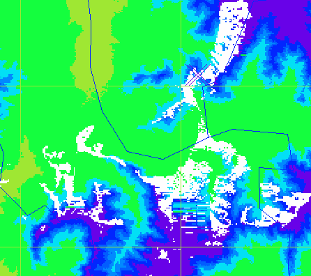
這裡(x)所能見的(白),鄉鎮界(黑)Points visible from here (x) marked in white. Grid=230,235km W; 2670,2675 N km TWD67. Black=township lines. 抱歉初次用 Sorry it's my first try with GRASS GIS. Data source: DTM files were obtained from professors I met at GIS conferences.
越遠, 能見這些點 Further away, we can see these points: Google™ 地球 KML 圖 map, (產圖程式 program that created the map.)
標高 方位角 距離 景點(中、英)
ALTI AZIMUT DIST NAME (Chinese, English)
TUDE H      ANCE
m    deg°   km
2300  63.40 12.2 稍來山南端 Shaolai Shan south edge
2938  93.6  20   基隆山 Jilong Shan
3283 140.60 43.9 干卓萬山 Ganzhuowan Shan(八瘦)
3368 146.48 46.2 卓社大山 Zhuosheda Shan (九峨)
1064 147.68  5.5 黑田山 Heitian Shan
 556 152.7  25.9 虎子山 (台灣地理中心) - Huzi Shan (center of Taiwan)*
3275 153.18 74.7 內嶺爾山 Neilinger Shan(十崇)
2357 153.73 51.5 加年端山 Jianianduan Shan
3255 154.08 73.9 馬路巴拉讓山 Malubalarang Shan(六易)
3619 159.42 65.7 東郡大山 Dongjunda Shan (十崇)#13 (很少像飄的) (Almost never looking like a floater.)
2017 159.81 38.2 大尖山 Dajian Shan
3437 161.34 69.1 櫧山 Zhu Shan(七峭)
3483 162.65 77.5 馬利亞文路山 Maliyawenlu Shan(九平)
3254 163.23 68.6 無雙山 Wushuang Shan(九嶂) Pic of Camel 的登山旅遊記事
2112 164.07 39.6 水社山主峰 Shuishe Shan (peak)
3785 164.34 76.1 馬博拉斯山 Mabolasi Shan (十峻)#4, 中央山脈#2
2483 164.65 49.3 治茆山北峰 Zhimao Shan north peak
3805 165.56,78.7 秀姑巒山 Xiuguluan Mtn. 中央山脈最高峰 #3, 中央山脈#1
2909 166.34 49.9 治茆山 Zhimao Shan (再 1.00 度就:)
2863 167.34 50.8 治茆山南峰 Zhimao Shan south peak
 775 171    36   日月潭 Sun Moon Lake*
3952 173.25 79.4 玉山 Yushan* #1
1126 186.49  5.8 頭拒山/頭櫃山 Touju/Tougui Shan
 250 238.82 81.8 麥寮六輕煙囪 - Formosa Plastics 6th plant smokestack
 480 246.46 12.3 三汀山 Santing Shan
  37 247.20 59.7 王功燈塔 Wanggong Lighthouse
     247...      地球村公寓大廈 彰化市彰南路二段348巷130號
                 王功新生地北側七座風力發電塔 -
                 Wanggong seven windmill generators:
                 (燈閃每 3.0 秒 Lights flash every 3.0 seconds) OpenInfraMap.
  90 247.94 58.8 (最西 westmost)
  90 248.32 57.2 (最東 eastmost)
空氣乾燥始得見, 有的一年僅一二見。 (三千公尺以上的山)若下雪,望遠鏡得見。 These points visible only if air dry. Some can only be seen once or twice a year. Snow, if any, on the 3000+ meter peaks, is visible in binoculars. "*" = 地平線之下 below horizon. (Shan means mountain.)
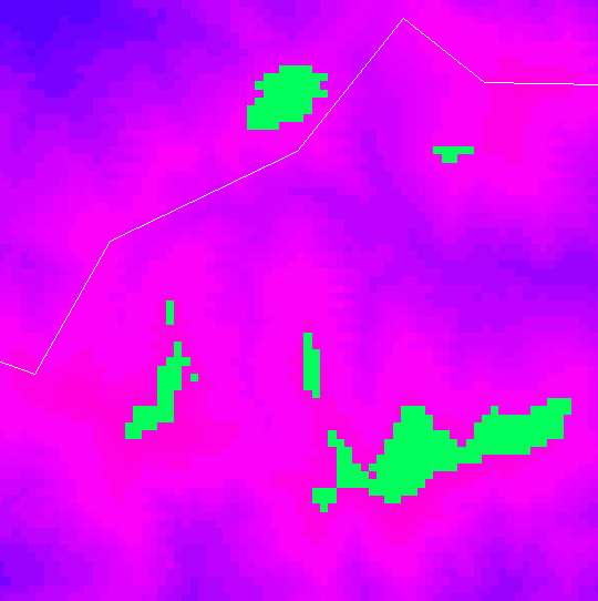
內嶺爾山至馬路巴拉讓山之嶺線位於花蓮縣。The Neilinger Shan to Malubalarang Shan ridge line is in Hualian County. 縣界以白色於此圖 Map: White: Nantou / Hualian County boundary. Green: visible areas. 3 x 3 km square: e=270 w=267 n=2611 s=2608 km TWD67, 「十崇」之二。
I remembered to subtract the earth's curvature from the DTMs...
heywhatsthat.com 2015:
Last modified: 2024-10-24 05:32:39 UTC