前言 Preface
我們很好奇, 台灣台中市北屯區軍各路怎麼分布的?
We're rather curious, what is the distribution of the Junfu roads in Beitun District, Taichung, Taiwan?
地圖 Map
 KMZ
圖
KMZ
圖
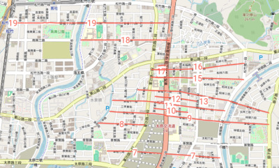
圖一: 軍福七至十九路(2025 年)。
Figure 1: Junfu 7th through 19th Roads as they
looked in 2025.
不規則的路 Exceptionally aligned roads
唯一轉而與其他者交叉是軍福十七路。
The only one that turns and crosses the others is Junfu 17th Road.
不存在的路 Missing roads
軍福路本身不見 Junfu Rd. itself: gone
軍福路本身, 於其上空興建 74 號快速道路後換名環中東路二段。
As for Junfu Road itself, it was renamed Huanzhong East Road Section 2 after Highway 74 was built above it.
十四路 14th Rd.
無軍福十四路 (不吉祥?)
Note there is no Junfu 14th Rd. (unlucky?)
重建之 Estimating where it would have been.
2026 年現場和順路口處無路名牌, 又和福路門牌特別繞進去。
As of 2026 There is no road name sign at the corner with Heshun Rd., and Hefu Rd.'s numbers "reach in" and take care of the numbering.
略東採建和路二段219巷。
Further east, the name Lane 219 Jianhe Rd. Section 2 is used.
一到六路 Roads 1 through 6
另不知軍福一路至六路下落, 規劃改變?
And who knows the fate of Junfu Roads 1 through 6? Change of plans?
路名與門牌未作關聯 Road names not coordinated with house addresses
如果這是美洲, 很有可能各南北街, 其譬如過十五路時, 就達其 1500 號門牌, 過十六就 1600 等等。 可惜不是。
If this were the Americas, there would be a large possibility that when north south streets cross e.g., Junfu 15th road they would enter their 1500 block. Cross 16th, their 1600 block, etc. Alas, not here in Taichung.
程式碼 Program code
以此原始碼自開放街圖數據下載加工製本圖。
Here is the source code we wrote to get the data from OpenStreetMap and make our map.