本文假定一個城市,其路名、門牌皆空白,待我們制定最佳編訂方式。我們結合台灣【幾巷幾弄】與猶他州【門牌座標即路號】等各系統優點,套在工業區弧形路網上,座標軸折疊, X, Y 共用。
Let’s say street names and house numbers are all empty. Have you, the reader, thought about how to number them? We merge Taiwan’s “Lane P Alley Q” with Utah’s “raw coordinates as road name” and other house numbering / road naming systems from around the world. We remove one of the plane coordinate axes and bend the other, getting a single axis to do double duty. In the lab we then drape this all upon the curved streets of Youshi Industrial Park, Taichung, Taiwan, just as an experiment. To the person in the street this is a system that cannot be simplified further, and does not require a cellphone.
弧形以 OpenStreetMap 逐路口當控制點,由 OGR/GDAL/SpatiaLite thin plate splines, Viking GPS 出圖。犧牲【幾公尺/多少門牌】固定比例,換取【平行的路,門牌同步】。
To handle the curvature we used each road intersection’s OpenStreetMap data to make ground control points, and then OGR/GDAL/SpatiaLite thin plate splines, finally making maps on Viking GPS. GIS staff use the same house number / road number coordinates as the general public. In the past we might have wanted a constant meters-per-house number ratio. Now more important is parallel roads should have lockstep house numbers, even when curved.
本系統如方格紙,定位免手機免地圖。「1450路654號」欲表達途徑時亦能作「700路1600街600巷1450弄654號」,而若誤倒置成「654路1450號」,仍相鄰。惟山區無方形路網,本系統不如傳統【幾巷幾弄】。
In the flatlands it’s like walking on a sheet of graph paper. No need for a map. But in the mountains or crooked road areas our system can’t beat Taiwan’s traditional “Lane P Alley Q”. However in the flatlands we can also combine the systems, allowing packing in a path to hard-to-find addresses: “No. 654 Alley 1450 Lane 600 Street 1600 Road 700”, and all the fire department responder needs to double check is, “Did I hear you say 1450 and 654?”
| 相關檔案 Related files | DIR |
House numbering planning, they don’t teach it even at urban planning institutes3. And then the municipal office sends someone out with pad of paper to number houses: disaster! One that even the best maps can’t fix. And then there are the GIS professionals, never imagining what if they were tasked with creating an addressing system from scratch.
(Note the following proposal is more advanced than current local house numbering regulations allow, so is just for reference.)
去除各地缺點後,套在弧形工業區路網之前,必先放棄前一波門牌改革【幾公尺/多少門牌全區固定比例】概念,換採【平行的路,門牌同步】,如橢圓形操場逐跑道,內線門牌會較密。另外,因弧形,故本文南北東西、甚至左右,都不提,僅講框內側為雙號…
After eliminating the pitfalls of each system, we add our own algorithm (K, David, 2026), and then see if can deal with a curved industrial park. Yes it can, but we must first give up on the earlier revolutionary numbering practice of a fixed numbers-per-meter ratio. That was a good reform back in the past, but we’ve got an even higher principle to follow now: “Parallel roads, parallel numbers”.
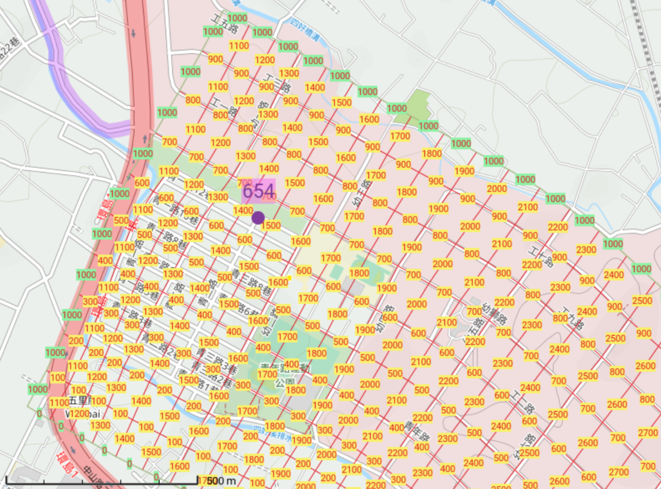
圖1: 紅、黃:路號兼門牌座標方格網。所有的路依序自綠色虛擬 L 字型「1000路」分出。不但採單象限角,且 X 與 Y 值不重疊,又不跨 0, 門牌全正無負,免分南北東西、幾段路。地址舉例:1450路654號(側門:656路1452號)。底圖:台中市大甲幼獅產業園區 OpenCycleMap “歷史” 路名。註:本研究僅限實驗室,未及現場。
Figure 1: Red, yellow: our road naming / house numbering grid. All the roads, in numerical order, branch off green colored L-shaped imaginary Road 1000. We restrict ourselves to the first quadrant and also don’t allow X and Y to overlap. Nor do we venture past 0, keeping the entire system positive: no need for N. S. E. W. street name prefixes. House example: No. 654 Road 1450 (side door: No. 1452 Road 656). Base map: Youshi Industrial Park, Dajia District, Taichung City, Taiwan.
如圖1,先畫一條路(綠色 “1000”),繞著社區的外圍,把社區框起來。該路暫時尚未命名。該路走著,框的內側,依台灣習俗,發出號碼巷: …200巷、300巷…6 7 (且我們指定本(框內)側為雙號側,因此整個系統所有路號跟著註定為雙號,全城無單號路。框外則禁編,以免與框內產生雙胞胎門牌等。圖1【0 路】同樣不許跨越。)
As in Figure 1, we first draw out a road (green, “1000”), going around the edge of our community. We won’t name our road just yet. As we go along the road, on the inside of the frame we will make branch roads Lane 200, Lane 300… (This is a highlight of Taiwan practice: we’re on the even side of the road, so between houses 486 and 490 there might be a Lane 488 instead of a house. And we are choosing to make our lanes branch off at every hundred, to keep things neat. Note we choose 200, 300… and not 201, 301… You the reader certainly agrees that looks more sharp, no?
到了將生出1000巷的時候,我們不但生出它,也8轉入它,亦即沿著框角90°轉彎,然後繼續,框的內側照樣生出1100巷、1200巷…
So OK, we’re making our numbered lanes and what do you know, after making Lane 1000, it is time for lunch or something, and we not only make Lane 1000, but also “turn” 9 into it, both as in “turn the steering wheel”, and as in “become”. Fine. Anyways, we proceed nonetheless, creating branch roads on the even side, Lane 1100, Lane 1200…
巷均取名妥,而在我們的系統,所有的路同等。既然同等,無路與巷之別,故均改稱路。回顧圖1,剛走綠色路,比較周圍的路號,其唯一可能的路號就是我們貼的「1000路」, 10該1000路也就是我們門牌座標【折疊單軸】。11 接著能製圖:
OK, but we still haven’t named our road yet. Now didn’t we just also dart into Lane 1000? But how can Lanes give birth to more Lanes? (Not in Taiwan.) Ah! I got it: let’s call them all “Roads”. Looking back at the map we observe the position is correct. So calling the green road “Road 1000” makes sense.12 That Road 1000 is our so-called “single folded axis” coordinate system’s single axis.13 OK, we’re ready to make maps:
ogr2ogr -tps (thin plate
spline) 使控制點夠密合。圖以 Viking GPS 輸出。 17 18ogr2ogr -tps) we fit our grid tightly on the
road network and output maps via Viking GPS.相應路網(圖1), 100 × 10022 門牌號碼的街塊 (city block), 長度自 53 至 134 公尺不等。乍看數字,民眾無法【看幾號,知幾尺】,惟其變化是逐漸的,並非忽長忽短,而換來的是路網能與門牌座標同體。一些特點如下:
As seen in Figure 1, the length of a hundred number long city block (50 on each side, odd and even) now becomes flexible, from 53 to 134 meters in this particular Industrial Park. But isn’t that just “parallel roads, each numbered independently” of the (Taiwan) past? No. It is more like the lanes of an oval athletic running track, with differently individual lengths, but a common formula holding them together23. OK, let’s see what extra features we also obtained,
In Figure 2, we see we also can, if needed, add flexibility to our road naming system.
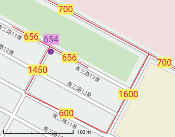
圖2: 一棟門牌為654號之房屋。 紅、黃:新路名兼門牌座標。底圖 OpenCycleMap 含 “歷史” 巷名。
Figure 2: A house, № 654. Red lines are proposed road names, and at the same time the address graticule. Background OpenCycleMap shows original road names.
本系統【免手機免地圖】。那麼,1450路 (圖2) 尚未由公園打通之前, 1450路654號, 若欲【免圖】引導, 得暫時另外寫成:
E.g., the address
we can in fact write in many different ways. See Figure 2.
That’s right. We grafted in the cleverness of Taiwan’s addressing format, giving addresses “built-in navigation systems” all in just a few words.
And when might we use such longer addresses? When Road 1450 (Figure 2) hasn’t yet been blasted through the park yet, and we are worried that people on Road 700 looking for Road 1450 will be disappointed, that’s when.
And who shall use such longer detailed addresses? Shall the government issue them as the official address of a house, or are they only to be used between friends? Our article here today has no opinion, but must warn, once the road through the park is blasted through, the longer address becomes a superfluous roundabout navigation instructions. However using the shorter address early, before the road is blasted through, means people will need to user phones and maps to find the home, violating our promise of “no phones or maps needed.”
In fact in Taiwan local laws “台灣各縣市政府【道路命名及門牌編釘自治條例】” (1999–2026) say the Road, Street, Lane, or Alley name choice is determined by pavement width! So after the road is blasted through the park, what we wanted to now call “1450 Road” we must still call e.g., “1450 Alley”. But the good news is at least the street sign needn’t be the full “Alley 1450 Lane 600 Street 1600 Road 700”, because it no longer belongs to only just one branching system!
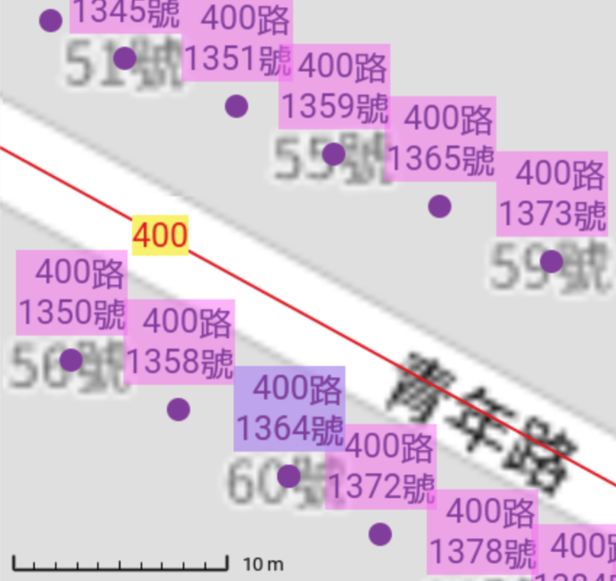
圖3: 紅、黃:新路號兼門牌座標; 紫: AI 編的門牌;藍:門牌條例中之末碼四者25; 黑: “歷史” OpenStreetMap_Carto 圖。
Figure 3: Red, yellow: New road name / house numbering grid; purple: address recommendations; blue: a “fearsome final digit four26” house number; black: OpenStreetMap_Carto map containing current house numbers.
Our homebrew “AI” is rather naive, Houses with (one) coordinate slightly less than q00: give them an even numbered address on Road q00, odd for those slightly higher.29
本文是先帶讀者認識座標框細節。 以如 BGC,制定個尚未周全號碼範圍。最後特此本段文字提醒懸崖勒馬:實務上應設如 (25…, 75…) 為中央,而框, 50…, 放海域、山地,莫讓都市發展越框導致無號可編。

圖4: 2500, 7500 路口改設工業區中央,延後城市發展越框外。 框改 5000, 於圖外。 CycleOSM “歷史” 路名圖。
Figure 4: Roads 2500 and 7500 now placed at the center of the Industrial Park, delaying development reaching the frame edge, now 5000, located off the map. CycleOSM “historical” road name map.
本文 2026 年 7 月 2 日發表於 TGIS 2026 台灣地理資訊學會年會暨學術研討會。與主持人林峰田教授合照: 1, 2. 他也住過 Evanston, Illinois.
程式碼, KMZ, 等網址: https://www.jidanni.org/geo/house_numbering/grids/tw/taichung/dajia/youshi/
This paper was presented July 2, 2026 at the TGIS 2026 conference. Photos with session host, Prof. Feng-Tyan Lin: 1, 2. He also lived in Evanston, Illinois.
Source code and KMZ etc. files: https://www.jidanni.org/geo/house_numbering/grids/tw/taichung/dajia/youshi/
讀者怎麼記得哪面單哪面雙呢?參考1000路就對了。圖1看到當初其逐雙號巷從哪一側分出。免再講什麼南、北、東、西、左、右側了。且一旦繼續弧下去,東變北,南變西,更沒意思。左、右側更不要講。該兩字,本文章除了本段之外,隻字未提,僅講「框的內側」,而在這方面相左才是 “台灣各縣市政府【道路命名及門牌編釘自治條例】” (1999–2026) 了。另,因所有的路是從同一側發出來,框內側,雙號側,所以所有的路是雙號路,如656路。我們的系統不允許單號路之存在。如果起床發現單號馬路,那是別人的世界,昨晚去哪裡忘了。
How are you, the reader, supposed to remember which side of the road is even vs. odd? Check Road 1000! In Figure 1 we saw back when we first numbered that road, the even numbered lane came off of which side. No need for talking about “the north (south, east, west, odd, or even) side”. Indeed, the more our curved roads here in the Industrial Park curve, north will become east, south will become west, so drop those old fashioned concepts right now please. Our article doesn’t use them, (unlike some laws, “台灣各縣市政府【道路命名及門牌編釘自治條例】” (1999–2026).) So what can we use to remember even and odd sides? Ah, simply: inner side of frame (L shaped road 1000) is even. And as all roads branch off from the even side, all roads in our system are even! No odd numbered roads allowed. If you wake up and there are odd numbered roads, you are in another world. Did you remember where you went last night?
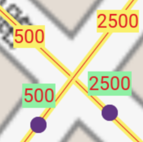
圖5: 兩棟房子, 建路中央。 十字路口,改只有 L (V) 字型通行。
Figure 5: Two houses, in the middle of roads. This four-way intersection becomes a L (V) -shaped corner.
確實能同時存在,但必須封路, 變 L 字型通行, 且 L 之內側也對著1000路之 L 的內側。 該 500 與 2500 之對面會是 501 與 2501,惟路名僅允許雙號者,故只有兩點才能 同時有 P 路 Q 號及 Q 路 P 號同時存在現象。
Indeed can coexist, but we must close this intersection, only allowing traffic in an L shape. The L whose inner side faces the inner side of Road 1000. The other two houses across from 500 and 2500 here would be 501 and 2501. But our rules say all roads must be even numbered. Hence those odd numbered houses would not produce the “№ Q Rd. P coexisting with № P Rd. Q” phenomenon.
後綴 -00, -01 房屋不出現於十字路口, 僅出現在 T 字型路口,或長方塊中。
==500路===     =====500路===
303至499號  4  對面302至498號
==300路===  2  300號
203至299號  0  對面202至298號
     201號  0  =====200路===
103至199號  路 對面102至198號
==100路===     =====100路===
Houses suffixed -00, -01 don’t appear at 4-way junctions, but instead only at T-junctions, and mid-long-block.
==Rd. 500===  4  =====Rd. 500=========
Nos. 303-499  2  opposite Nos. 302-498
==Rd. 300===  0  No. 300
Nos. 203-299  0  opposite Nos. 202-298
     No. 201     =====Rd. 200=========
Nos. 103-199  R  opposite Nos. 102-198
==Rd. 100=== d =====Rd. 100=========Just like as we get rid of one of Taiwan’s biggest shortcomings, 123-1 auxiliary numbers, we also pick up its good habits. E.g., if there exists a T junction with Road 300 coming off the side, then there can be no house number 300 there, unless we seal the road, Figure 5.
A community building index would look very tidy,
超市297 296空地
回收299 298敏宅
馬路301 300馬路
油站303 302商店且能維持均正整數。
supermarket 297 296 vacant
recycling   299 298 residence
road        301 300 road
gas station 303 302 shop
and we get to keep our system all positive integers.
101, 201, 301 號則「犧牲於 100, 200, 300 路之寬度之下」。只能在 T 型路口,或中段無路口之長街塊, 允許其存在。
Nos. 101, 201, 301… are “sacrificed” for the width of roads 100, 200, and 300, and only appear at T-junctions, and long blocks with no junctions.
假如典型街塊該採201至297號,對面202至298號,又假如200路不存在,也不是什麼 T 字型路口,而兩面都是房子,號碼連結不斷。那麼,200號至298號對面就會是199至297號,不乾淨!較好則是對面是201至299號,都2-開頭了吧。
If we instead declared a typical city block to consist of numbers 201…297 on one side, 202…298 on the other, and, say Road 200 was not present. all there was there was house after house, well then across the street from 200…298 would be 199…297. Yuck! So that’s why across we prefer 201…299, to keep this all a “2– family affair.”
見圖1及 KMZ 檔,有一條現稱【工六路】,自 1600, 200 路口至 3100, 270 座標。 我們勉強能稱之為270路, 但再加歪的話就只好放棄, 換以歪哥人名命名!
當然定地面控制點時先排除它。
Looking at Figure 1 and the KMZ you will see a road currently named 工六路, starting at the corner of 1600 and 200, ending at 3100 and 270. Well, I suppose we could grudgingly call it Road 270, as at least that’s the grid value the better behaved part of it seems to be aligned on. Any more crooked though and we would forced to just name it after some crooked politician!
Naturally we excluded it when creating our ground control points.
如上述既然採「一個街塊預留100個號碼,這面50個,對面50個34」,那麼我們也好奇35,相對如芝加哥市,固定 “100 numbers per 660 foot [201 公尺] block”36, 我們則有彈性,
那麼如果建築法規規定一棟最窄 5 公尺。一面滿 50 棟至少 250 公尺。我們在 134 公尺已預留了 100 個號碼,亦即免怕動到「之幾」之門牌了。
As above since we chose “one block shall have 100 house numbers, 50 on either side” 38, well, compared to e.g., Chicago, with their fixed “100 numbers per 660 foot (201 m)block”39, we’ve got flexibility, but let’s see how the numbers stack up,40
Anyways, if the laws state that the minimal building with is 5 m. then 50 houses means 250 m., and we provide 50 numbers in 134 m, so there should be no need to use ugly 123-1 style auxiliary numbers.
續上邊,怎麼辦?核發第一枚門牌前能不能重來,屆時不輸在起跑點?圖4: 可選市中央一大路口,或許也靠近市政大樓,當新 2500 與 7500 路口-我們預測平地四向平衡發展。 且要事先規劃,如果遲早要在一定升等, 為 25000 與 75000 路口, 那麼不要客氣, 現在直接升等,免分二階段, 擾民。
Continuing, So, realizing our mistake, how might we “rebase” all our numbers before we ever begin putting them on people’s houses? Figure 4: Pick a prominent intersection near the center of town, close to City Hall perhaps too, as the corner of Roads 2500 and 7500 - a flat land model that expects future city growth evenly in each direction. Be sure to plan ahead: if that corner really should be 25000 and 75000, do so from the start, rather than years later expecting the public to be happy about a second “grand renumbering”. OK, back in Youshi, let’s reassign:
還有,數字長度要一致。 如 654 知其來自 501…999 而非什麼 1…4999 (原應限 1001…4999.) 而 “0654” 可別想,因為人傳人,前零易脫落。那麼,建議採 {101…499, 501…999}, {1001…4999, 5001…9999}, {10001…49999, 50001…99999}, {100001…499999, 500001…999999}, 等等42。是的,不管「浪費」前 10% 數字 否。 屆時想做舊 ↔︎ 新對照表,能依長度辨認新舊值得吧。 另外,邊緣數字(1000, 5000, 10000) 我們都避免, 省很多數學。 回到幼獅,我們要重新定:
Furthermore, by using all the same length numbers, it will be clear that e.g., 654 was from a 501…999 range, and not some 1…4999 range that really should have been 1001…4999. And no, do not dream of writing “0654” as any kind of robust address format. OK, so here are the recommended ranges, {101…499, 501…999}, {1001…4999, 5001…9999}, {10001…49999, 50001…99999}, {100001…499999, 500001…999999}, etc.,43 yes, even if that “wastes” the first 10% of the numbers. It will pay you back when making old ↔︎ new system translation tables. And simply stay off of the edge cases (1000, 5000, 10000). As you see we add 1 to avoid even needing to think about them.
而該單軸 L 字型框,本身之軌跡與方向, 原來 “⮣”, 值 1000, 現在變成 “⮥”, 值 5000. 社區服務中心, 原址 700 路 2150 號, 今改 7500 路 2450 號了。
The single axis “L” path and direction originally “⮣”, value 1000, now becomes “⮥”, value 5000. The community service center, originally № 2150 Road 700, mow becomes № 2450 Road 7500.
英文地址
美國有時省略 No. / №,
但本文保留著。
Yes, in the USA
could also be written
but in this article we retain the No. / U+2116 NUMERO SIGN: №.
以免文章失焦,今不談門牌版面內容、室號、郵政,戶籍地址格式, 等等。
To avoid this article losing focus, we avoid discussing address plate content, room/unit numbers, postal / household bureau address format, etc.
門牌條例也無法保障對面門牌不會差幾百號,何況平行的路,門牌同步。公所派員持筆記本編門牌,千古恨。連雙胞胎門牌通通來。↩︎
而在我們的系統裡,
該巷巷號,因是從遠方【1000路】分出來的,不管斷斷續續的否,均同一巷號。↩︎
這就是台灣系統的精華,號碼巷與門牌號碼同體。↩︎
我們不採201巷、301巷,因為我們認為200巷、 300巷比較整齊。↩︎
也不必急轉彎,可慢慢轉,以維持我們的單軸理論(Varma (2026))。 也不見得要轉剛好 90 度, HP Fire Dept. (2023) 為例。↩︎
We don’t need to make a sharp turn. A gentle turn might help us better prove our “single axis” theory, (Varma (2026)). Nor must we turn exactly 90°, HP Fire Dept. (2023).↩︎
一般該框應遠離社區(積 (2024))。 遠到社區萬年後也不會延伸觸及它。因越框的部分無法發門牌號碼,否則與 框內地址重複(K, David, 2026)。故採單象限 角。 這次則特別設於近郊讓讀者同圖1看得到。↩︎
其實上邊講的逐巷子也不一定都要鋪設。留在地圖上僅當紅色線條也可以。 它們主要的功能是做我們門牌座標方格網。再則,鋪設後,寬度可能很寬, 我們先均改稱【路】,與1000路同等,甚至免鑽牛角尖定義什麼叫路、街、巷、 弄, 如 “台灣各縣市政府【道路命名及門牌編釘自治條例】” (1999–2026), 生長過程一直改名, 如昆蟲脫皮。 均先稱【路】好了。↩︎
Normally that frame (single L-shaped axis, Road 1000 here) should be farther away from the community than here. (積 (2024)). Far enough so even many years later community development won’t get near it. Because once you leave the frame, there is no way to number houses without creating twins (K, David, 2026). That’s why we chose only the first quadrant. This time we especially made the frame close to town so it would fit on Figure 1 so you the readers could see it up close.↩︎
Actually we don’t really need to build any roads: those green and red lines are simply our graticule, that governs how we name roads and number buildings. Furthermore, once you really bulldoze them, they might be quite wide. So we’ll beat the rule book “台灣各縣市政府【道路命名及門牌編釘自治條例】” (1999–2026) to it and call them all Roads right from the beginning, instead of needing to upgrade the name from Lane to Street to Road according to width, like some molting insect.↩︎
OpenStreetMap 門牌點源自台中市政府民政局開放資料。↩︎
對外。說穿了,對內,亦即與 GIS 操作時, 1000 以下就是 Y, 1000 以上就是 X. 1000 本身呢? 不敢碰! 一般不會那麼靠近社區,且此案採 1000 當折疊軸,因剛好橫的路能用三碼內標示(其實,不良示範。)另一案也許採 3700, 看地形需求而定。反正三個象限鎖定,唯一能拓展是一直增加路號,從目前3100×1000門牌網向更高方向成9000×1000. 若再向東延伸,就需變 5 碼了。通常如果沒有其他考量,四碼我們會把 2500/7500定近城市中心,五碼則25000/75000。↩︎
不是 3100 東,也非 3100 北,而只是 3100, 又是(其交叉路的房子用的)門牌座標值,也是未來的路號:原幼九路要變成【3100路】,唯一的名字。↩︎
這個都建立了之後,我們就脫離了 WGS84, 座標變簡單了: (1450,656) = (656,1450).↩︎
Those OpenStreetMap address points of course originated at the Taichung City Civil Affairs Bureau’s opendata.↩︎
To the outside. But to the inside, interacting with GIS systems, yes, below 1000 is Y, above 1000 is X. What about 1000 itself? Keep your distance and you’ll be fine. Normally it wouldn’t be close to town anyway. And, us choosing 1000 for the folded axis in this project is because we noticed there were only about 10 cross streets, so we could keep their names all 3 digits long. Bad idea. In some other project we might pick oh, 3700 to be the folded axis. Depends on the geography there. Anyway we have sealed off three quadrants leaving only one direction for growth. So currently we have a 3100×1000 grid and at most have it become a 9000×1000 grid before needing 5 digits, which if we started adding in, would then would get us in trouble if we ever upgraded the whole system to 5 digits… Anyway, with all things being equal, a town should have its center at 2500/7500, or 25000/75000 etc.↩︎
Compared to e.g., HP Fire Dept. (2023), where their ordinances regulate a single skew, our skew differs at every point. No something easy to codify into law.↩︎
As in Figure 3, we easily predict a house’s future number, simply from its coordinates. No need to consult road network data, nor look at aerial imagery. A house that has coordinates slightly lower than 400 will get an even Road 400 address.↩︎
“台灣各縣市政府【道路命名及門牌編釘自治條例】” (1999–2026) 所顧慮末碼四 者,惟今不談,免得文章失焦。↩︎
We highlight a tetrophobic …4 address, which Taiwan’s addressing ordinances “台灣各縣市政府【道路命名及門牌編釘自治條例】” (1999–2026) have a special clause for. But we will not discuss that today, to avoid our paper losing focus.↩︎
我們很容易預判編號後之門牌。如圖3,完全不參考路網數據,也不看空照圖。光從門牌座標略低於400,馬上給予隸屬400路之雙號門牌。↩︎
但是座標越低於 q00, 其大門越可能對著 (q-1)00 路,或說不定此處根本缺什麼 q00 路。此時不能繼續光以座標定門牌,而要打開空照圖,或查該屋方位角資料。另外,靠近十字路口,一棟房子座標可能同時靠近各自 q00. 總而言之, 如其他 AI 一樣,頒發門牌須慎重,仍請戶政人員一一過目。↩︎
However the lower you go away from q00, well maybe their door actually opens toward Road (q-1)00, or maybe there is no Road q00 here in the first place. So we can’t just blindly use coordinates to compute future addresses, but must haul out the aerial imagery, and/or check house orientation angle data. Also, close to four-way intersections, both coordinates might be close to their own q00. Anyways, like with all AI, the housing officer needs to double check each address recommended by the system, for sanity, before officially issuing the address.↩︎
我們那個單軸也可以從地球中心開始。出土後,號碼從負變正,到了200樓高才橫轉,繼續上述的途徑。這樣單軸也囊括樓層,變立體了。地下一樓 B1 = -1, 歐洲 Ground Floor (GF) = 0. 台、美 1F = 1, 0 不編。↩︎
We might have our single axis start at the center of the earth. After popping out from the surface negative numbers become positive, and upon reaching 200 it suddenly turns horizontal, and picks up where our story began. Thus we now are able to describe all three (housing) dimensions. Let’s see, basement floor B1 = -1, European Ground Floor (GF) = 0, Taiwan and US 1F = 1, with 0 skipped.↩︎
其實通常 98, 49, 49 個,因橫路也佔
00 與 01.↩︎
我們今天用 GIS, 唯一碰到「公尺」的時候,或其他距離單位,除了我麼的弧形座標之外。↩︎
且芝城通常僅用如 3600…3660, 3700…3760… 斜的路才用到 3799. 而 201 ÷ (60 ÷ 2) 得知芝加哥每 6.7 公尺預留門牌號碼。↩︎
Actually 98, 49, 49 because
00, 01 are occupied by the
crossroads.↩︎
Furthermore, Chicago only uses e.g., 3600…3660, 3700…3760… and only with diagonal roads does one reach 3799. Let’s see. 201 ÷ (60 ÷ 2) we learn Chicago reserves one number per 6.7 m.↩︎
This is the only time today that we’ve dealt with meters, or any distance, other than our curved coordinates.↩︎
However that’s beyond Figure 1, so the reader needs to check the KMZ.↩︎
Some large road numbering / house addressing grid examples: South Dakota, North Dakota.↩︎
而等於 1000 呢? 較複雜,幸好我們不建設那附近。↩︎
And 1000 itself? It’s complicated. Fortunately we don’t do construction near there.↩︎