Introduction
Examining house numbers in (Metro Manila) Philippines, we find they sometimes get rather high. E.g., 8000 here, 9000 there. Perhaps not as high as in the Americas, but plenty high still. Let's see how they manage to get so high.
House addressing grids
-
Malate, Manila
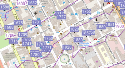
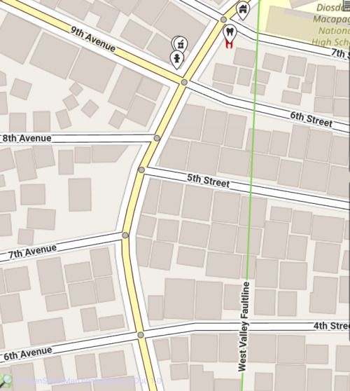
Address contour map reveals parallel house addressing seen in Malate, Manila. OSM map. Before we talk about grids we will talk about bands. (In the above image we only analyze the house numbers lying on north-south streets, leaving the east-west streets for some other day.) Using OpenStreetMap
addr:housenumbertag values, we constructed these "hundred block" band contours.So we see this part of the City of Manila indeed does have parallel house numbering on parallel streets. The only slight outlier is 1928 Jorge Bocobo Street, forcing our 1900 contour line to lurch north. By the way,
Methodology for address contour map
It took a whole month, for me at least, to figure out how draw address contours, when given just
addr:housenumbernodes (address points), and ways (building outlines (which we then proceeded to use theST_Centroid()of.))You see one normally draws contours upon e.g., Digital Elevation Models, etc. -- rasters. Here all we started with was a handful of address nodes -- points. We got the contours by "pretending" the addresses were "elevations". Nice use of the Z axis I would say.
But then we only spent just a minute or two to write a filter for this particular dataset (Malate
addr:housenumbers).- Q: How did you filter in only the north-south streets?
-
A: Yes, in some places streets and avenues run 90° of each other, but here streets are narrow avenues. So we can't just check
addr:streetfor an "Street" vs. "Avenue" suffix (yup, in the same tag, right along with the proper name, hmmm).Anyway we noticed that the range we were looking for of
addr:housenumberhere is 1500 to 3000. That nicely excludes the east-west house numbers in this particular study area. - Q: 3000? Why not just specify "> 1500"?
-
A: Because you'd never imagine what funny stuff those OpenStreetMap mappers put into that
addr:housenumberfield. To make things simple our first filter was "simple numerical addresses only, please" Yes, that threw away "2124-2126", "1919-A", etc.
Yes it would be tantalizing to trace back north to see where the 100 block's (or 000 block's?) baseline is. But we'll leave that for the next researcher.
We wonder how high the numbers go on their southward march below.
Maybe one day if we stroll into a fire department we will see hanging on the wall the master addressing plan finally revealed, like in Illinois, USA, below.
Grids on paper maps
Allow us to take a moment to see address grids expressed on paper maps from the USA.
![[Image: Highland Park IL USA Fire District map]](../../../us/il/lake/highland_park/images/hp_il_fd_north.jpg "Highland Park IL USA Fire District map")
Address grids on a Fire District map, Highland Park, IL, USA. OSM map. And not only hanging on fire department walls, but also folded paper maps in your automobile glove compartment:
![[Image: S. St. Paul, MN, USA address grid sample]](../../../../images/s_st_paul_mn.jpg "S. St. Paul, MN, USA")
Address grids printed in red on a paper map of S. St. Paul Minnesota USA. OSM map. ![[Image: SE Highland Park, IL, USA]](../../../us/il/lake/highland_park/images/hp_il_se.jpg "SE corner of Highland Park, IL")
Red address grid ticks on a paper map of the S.E. corner of Highland Park, IL, USA. OSM map. Note the oblique X axis. Problem: Such a powerful piece of knowledge, somehow missing on today's electronic maps.
Taiwan
How about countries where there are no address grids at all: the Philippines' nearest neighbor to the north, Taiwan. Every street starts with house number 1. Yes, parallel streets, but just like a horse race with different starting lines, even if each horse ran the same speed, any synchronization would be a coincidence. Example. 在台灣, 馬路兩側之門牌, 獨立發展, 舉例。
Furthermore, their left legs run at different rates than their right! (The house numbers on the two sides of a street often lose synchronization with each other. Sort of like "Married Filing Separately". ) Sad! More on Taiwan below.
-
Dr. A. Santos Avenue, Parañaque
Running this query we have enough points to indeed detect a (somewhat loose) pattern.
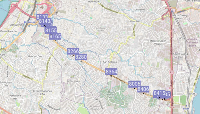
Addresses along Dr. A. Santos Ave. (formerly Sucat Rd.), Parañaque. OSM map. -
Observations
-
Strict odd addresses on the north sides, even on the south sides of roads.
-
It seems they are using about 100 numbers per U.S. mile (50 on either side of the road.) For comparison Chicago uses 800 per mile. I bet this was quite rural back when they numbered it. Now requiring 8123A, 8123B…
-
Yes, there are outliers, like 8006.
-
-
Suspicions
-
Wait, remember Malate? Perhaps this is the same grid, now in the 8000s so far south. But why do the numbers on A. Santos Ave. advance so slowly? Could it be that A. Santos Ave. is at such a glancing angle that the numbers don't advance much as one goes along it?
Possible addressing contour 8300 crosses A. Santos Ave. at a glancing angle. OSM map. But why don't they use the perpendicular component of their grid? Ah, perhaps A. Santos curves more that 45° from its initial orientation. But as the name stays the same, so must the numbering scheme.
Let's see, Chicago uses 800 numbers per mile. So 8000 would be 10 miles. Is Parañaque about 10 miles (16 km) south of (where the extrapolated 0 value would be, a little north of) Malate? Yes!
However in the northern part of Parañaque we also find
addr:housenumber4497addr:streetColonel E.L. De Leon StreetAnd nearby we see 5056, but also 8324!.
And even 5-digit addresses.
Anyway, one finds plenty of documentation about Chicago's grid. In Metro Manila the barangays are mostly in charge of house numbers, and how they were originally laid out in patterns spanning multiple barangays, well nobody in the government currently remembers.
-
-
Freeze the investigation
Don't you think this is a great homework assignment?:
-
Are the house numbers along A. Santos Ave. part of some larger Manila grid?
-
If not, then what are they related to?
-
Personally I bet we are simply seeing something similar to Makati. The person tasked with the 8000 series was sent off down this road or something. But we will leave the question open for others to solve.
-
-
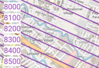
Sampaloc, Manila
House address grids observed in Sampaloc, Manila. OSM map. Here there is a quite rigid house address grid. For example, no matter what street we take, when it crosses España Boulevard we enter its 900 block. After we go past P. Florentino Street, houses addresses on either side of the street are in the 1000 block, etc. Indeed we can start building a table,
900 España Boulevard 1000 P. Florentino Street 1100 Piy Margal Street -
Ordinances
All I could find was an interesting
- An Ordinance Providing for the Numbering of Houses and Other Buildings in Quezon City. See also 2015 version, noted in Tan (2023).
which is a simpler system, but for Quezon City. Nobody in the Manila City Hall knows how the house numbers got their current order. House numbers are now maintained by each barangay too now.
-
Baselines
Extrapolating, the "0" line for one of the two axes would appear to lie in the Pasig River. Reverse engineering the other axis we'll leave for the next researcher.
-
Methods to create above map
-
https://taginfo.openstreetmap.org/search?q=addr reveals we want
addr:housenumber. We use that tag's data over and over in this article. -
On Overpass Turbo we query for it.
In the previous Malate "bands" example we used
addr:housenumberdirectly, after only minimal filtering. In the current Sampaloc example, we merely consult thoseaddr:housenumbers to get a firm idea of the hundred value of each street is, and then lay down a rectangular grid via ground control points (GCPs) which we establish at no less than three street intersections. -
See our source code and KMZ for all the steps.
-
-
-
San Andres, Manila
In an otherwise perfectly house number gridded area, sometimes a leak occurs. A house near a corner on an east-west street gets a number that belongs just around the corner on a north-south street. It could happen anywhere, world wide. Lesson: never simply assign a new number based on nearby addresses.

House number plate, San Andres, Manila. OSM map. BRGY 761 ZONE 82 DISTRICT V
2546
DON PEDRO ST.Like the official sequence of some 26th St's addresses being "1052, 1054, 2546, 1102, 1104". Did a side door with the front door's number become the new official address?
Here 2546 would make sense on neighboring Conchu St. (grid value apparently 1100) or Dian St. (apparently 1130) but not on this particular block of Don Pedro St. (where correct numbers would be 1100 to 1130.)
-
University of the Philippines Diliman
In BGC they are finally growing out of corner addresses. Let's give UP Diliman a grid to get them started numbering their buildings too! (Won't they need numbers to qualify for E911?)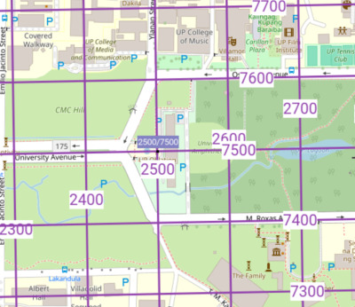
Proposed address grid for UP Diliman, with origin at (easting, northing) = (2500,7500), so as to fully occupy four digits. Example address: Villamor Hall: 2600 Osmeña Avenue. (Later we mention why that's on the even side of the street.) OSM map. 
Actually there are no eastings nor northings in fact. Just one single axis with a 90° fold in it, with value 5000. (More examples below. Yes, parts of our polygon have house numbers already. We only propose to number unnumbered buildings.) OSM map.-
Construction
East-west grid contours
We observe long straight parallel roads, and use them to define the east-west horizontal lines of our grid:
Avenue Utah Our US M. Roxas Avenue 100 S. 7400 74th University Avenue 0 7500 75th Osmeña Avenue 100 N. 7600 76th As one might suspect, we are indeed reserving 5000 to 9999 for our horizontal grid lines (and 0 to 4999 for vertical.) With 7500 strategically running down the middle.
In Utah, not only would Osmeña Avenue have value 100 North, it wouldn't even be called Osmeña Avenue, but instead simply "100 North", no "Avenue" even. (0 Avenue would be called "Main Avenue" or "Center Avenue" though.)
In our ("single axis") system e.g., Osmeña Avenue would be called "Lane 7600". But to help "sell" our system, we'll keep the name "Osmeña Avenue", not even asking to call it "76th Ave.", only insisting that its grid value is 7600.
North-south grid contours
Alas, for the north-south vertical lines we don't find very consistently spaced roads to fit a grid to. Therefore we will just plunk 2500 down at the Oblation Statue.
Yes, coordinate pair (2500,7500), the center of our grid, no coincidence, located right there at the statue.
And we'll use the same 125 meters per 100 house numbers distance we just obtained between University Avenue and Osmeña Avenue, for our vertical contour lines also.
Let's say city blocks were all 130 × 110 meters. Well we would declare our contours to also have such differential spacing. But here at Diliman we only find the aforementioned three east-west Avenues as a good anchor for a grid. For north-south Streets there is no strong pattern to bind to. So we'll just use the same meters per grid line spacing as we did for the east-west Avenues.
(In fact that also lets us justify our "single axis" abstraction. Something that would be a little odd (but not impossible) to justify if spacing changed abruptly from 130 to 110 as we went around the bend!)
-
Software implementation
In our Makefile the reader can see we have filled in some ground control points (GCPs) etc. parameters needed for us to be able to use OGR/GDAL to produce our grid, and Viking to display it. And as in all the other Makefiles in our article here that you are reading, we do it all on a GNU/Linux system, command line only, no (Q)GIS involved.
-
Clipping boundary
Most, but not all, of the campus' streets align with our grid, so in our Makefile we clip accordingly.
-
Final thoughts
So how does what we came up with match that Quezon City ordinance above? Well each street does start at 1, if one counts from our 5000 folded baseline.
-
-
Makati
While the street patterns in Makati are rather twisty and do not forms many grids, the house numbers are still indeed organized into fascinating patterns that we must discuss.
-
Four-digit addresses
Does this plate mean "House number 4541, Makati"?
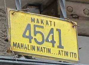
Address plate at 4541 Quintos St. Barangay Poblacion. OSM map. (Motto: "Makati, Mahalin Natin, Atin Ito". English: "Makati, let us love it, it is ours".)
Not unique
No. House numbers are not unique over all of Makati. Example:
8923 Sampaloc Street
8923 Taguig Street
Therefore the above picture's address plate must rather mean "4541 Quintos St., Makati".
But that's only normal. Towns have e.g., 105 Oak Street and 105 Maple Street at the same time all the time.
Mostly non-overlapping
But Makati addresses do show some sort of sequence too. (Here only looking at ranges of more than 10 house numbers in the OSM data):
8056..9074 Hormiga Street
8185..8233 Constancia Street
8439..8481 Trabajo Street
8737..8767 Paseo de Roxas
8760..8879 Santol Street
8845..8923 Sampaloc Street
8923..9516 Taguig Street
9179..9197 Catmon Street
9204..9238 Pateros Street
Turning to now to e.g., HERE WeGo maps, near the corner of Cordillera, Mayon and Maliking streets, Barangay Olympia, is a place where 1000, 2000, 3000, 4000, and 5000 house numbers appear to all start and head off in different directions.
But e.g., also at the corner of Osmeña and Teresa streets 1000 also starts, so there are several series throughout the city.
Let's see how they progress.
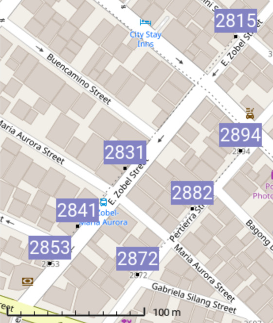
House numbers in Barangay Poblacion. OSM map. [Source code.] Above we notice numbers
2815 E. Zobel Street
2831 E. Zobel Street
2841 E. Zobel Street
2853 E. Zobel Street
going southbound. And then incrementing further,
2872 Pertierra Street
2882 Pertierra Street
2894 Pertierra Street
going back northbound. (Odd numbers on the right as we advance.) Interesting.
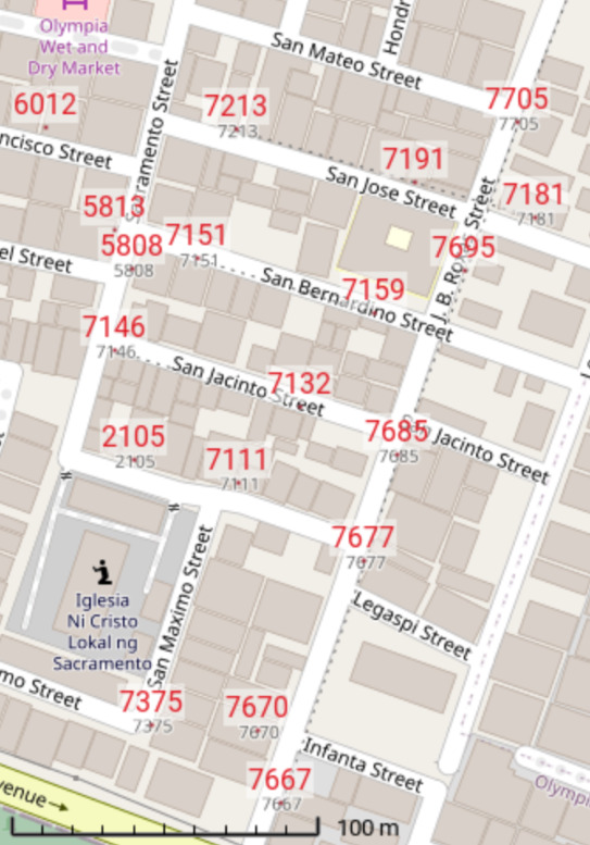
House numbers in Barangay Olympia. Those tiny black dots are address interpolation. OSM map. [Source code.] Hold on, I figured it out. It's a boustrophedon! You know, just like a PLSS township section ordering. See:
End← 7213 ← 7191 ← 7181 ← → 7151 → 7159 →↑ ↑ ← 7146 ← 7232 ← Start→ 7105 → 7111 →↑ A Makati boustrophedon sequence. How far does it actually extend off our screen? Even though the OSM address point data isn't dense enough here yet, we are finding boustrophedons. Venice-like perhaps.
So what kind of system is it?
Simple: odd on one side, even on the other. Perhaps several workers, you: 1000s, me: 2000s, they: 3000s, etc. wandering back and forth, to the end of each road, creating boustrophedons.
Worth fixing?
Well whatever system one comes up with would need to be ten times better to make it worth changing.
If of course one started from scratch one could use several grids, matching the several different orientations of the streets of Makati. Even curved grids for the curving street areas.
-
Barangay based addresses
It was in the news,
-
THEPHILBIZNEWS: FIRING LINE: To `hell' with Makati addresses
By Robert B. Roque, Jr.
April 20, 2023Premised on good intentions, the Makati City Council has passed an ordinance that will standardize the assignment of address numbers for all lots citywide…
That is why it pains me to say that this ordinance is a dead ringer to the aphorism: "The road to hell is paved with good intentions."
-
Makati City told to hold hearings on address law - BusinessWorld Online 2023/4/26
A copy of the ordinance could not be found on Makati City's website. [Dan's tip: first do a web search for "Makati ordinances". Then enter "2020-039" into the "Type Keyword or Document Code" box, not the "Search" box.]
OK, let's have a look at the Ordinance,
CITY ORDINANCE NO. 2020-039 (highlights)
-
This Ordinance shall be known as the Makati Address Ordinance.
-
All existing address numbers shall be replaced with the new standardized number.
-
All numbering origins shall begin from the barangay's right-most portion. [I.e., east-most!]
-
Parcel numbers should begin from one (1) from the numbering origin and ascend in a consecutive numerical sequence, e.g. 1-2-3-4-5-6, etc.
-
The numerical sequence shall be applied per barangay. Hence, each barangay shall start from 1 until all parcels/lots in the barangay are assigned with a number.
-
The numbering of lots shall have one continuous flow where the next address number is adjacent, across, or near the previous address number.
-
The numbering shall continue in a clockwise, east to west, outer to inner, direction.
-
For parcels facing each other or parcels along streets/roads, the numbering shall be alternated between the two sides of the road.
-
If there are no clear adjacent or near lots, the nearest logical lot within 100 meters should be selected as the next lot to be addressed.
-
The owner/occupant of the building/structure is hereby prohibited to take down, alter, or deface the address plate, to retain an improper address or to substitute any number…
And indeed as of 2025 they are hard at work implementing the Ordinance,
616
SGT. FABIAN YABUT CIRCLE
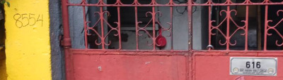
GUADALUPE NUEVONew 616 address plate (right) at former (pen on yellow post at left) 8554 Fabian Yabut Circle. My opinion: they are taking a system suitable for remote villages composed of an unorganized jumble of houses, and blindly applying it to the broad long streets of a big city, for instance Ayala Avenue.
Ayala Avenue has two different barangays on its north side, and another on the south. One would not expect the numbers on both sides of the road to maintain any relationship with each other anymore.
So what would be in store for Tower 6789, located at what is still for the moment 6789 Ayala Avenue?
Its new address plate might be
123
AYALA AVENUE
BEL-AIRBut further down the Avenue there also might be
123
AYALA AVENUE
URDANETAAnd on the south side of Ayala Avenue perhaps yet another
123
AYALA AVENUE
SAN LORENZOOne could argue that the same thing happens to EDSA addresses as EDSA passes city to city.
Well that's regrettable. EDSA should have a single system. But at least that's at a city level, not a barangay level.
Anyway I'm betting that they will back out of changing Ayala Avenue addresses.
Or maybe the old addresses will still be what the public sees, with the new system relegated to some box on some elevator permit.
-
-

Street name grids
-
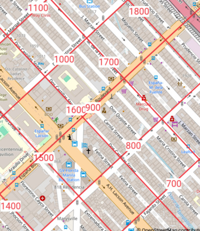
"K-" street area, Kamuning / Kamias, Quezon City

EDSA & Kamias Road, Project 1, Quezon City. OSM map. Source code and KMZ. Here we took the "K-" street grid and averaged its spacing. Useful one day say, if a strict address grid is desired. E.g., crossing grid line "G" eastbound one would enter the 700 block, regardless of where K-G street is.
If we also wanted regularized street names we are in trouble as we run out below K-1, and would be forced to use awkward K-0. Good thing we have also ran out eastbound before reaching K-L, as k-l looks like k-1, and K-O looks like K-0.
East-west block averaged length = 250m. If we choose 100 addresses per block, 50 on each side. Then on each side we have 5 meters per address. We might as well use the same rate for north-south streets. (Note BGC uses 2 meters per house number.)
-
Manila South Cemetery
The Manila South Cemetery is a pristine example to illustrate again our single axis system. It has
-
Streets B through J running in one direction, and
-
Streets M through Q, perpendicular,
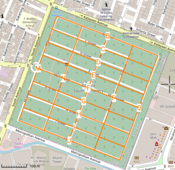
Manila South Cemetery's ordered perpendicular street names. OSM map. We simply "reconstruct" a theoretical Street A, as a single folded axis to both sets,
Our so-called "A Street", as the "folded axis". OSM map.[Source code.]
Yes as we go around the bend we change the letters per meter ratio.
Maybe the cemetery plots' numbers even e.g., enter the 700 block when one crosses G Street?
By the way, according to ASCII,
2 B 1 A 0 @ Fortunately there is no need for us to go below A Street for our folded axis.
-
-
Pasay street name grid
Street name grids observed in Barangay 183, Pasay. OSM map. -
Observations
-
Odd numbered streets (running NW/SE) intersecting even numbered streets (running NE/SW), like some cities in Cuba.
-
We modeled it with an algorithm. Alas, if the block sizes were constant the streets would match our grid lines.
-
In this area there is no coordination between street names and house numbers. No "700 block starts when you cross 7th St."
-
-
Recommendations
But let's say it did. So to also achieve "900 block starts when you cross 9th St." we would simply double our numbers per meter ratio.
So there you have it. In towns with odd/even perpendicular streets, to achieve an integrated house numbering / street name system, numbers would increase at twice the rate as elsewhere.
It's either that, or nasty missing chunks: 800-899 gone. 1000-1099 gone…
-
-
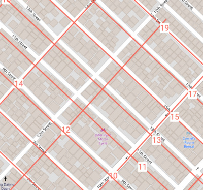
Caloocan street name grid
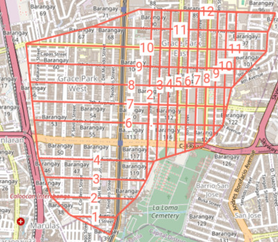
Street name grid observed in Grace Park, Caloocan. OSM map. 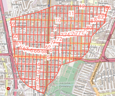
My revision. 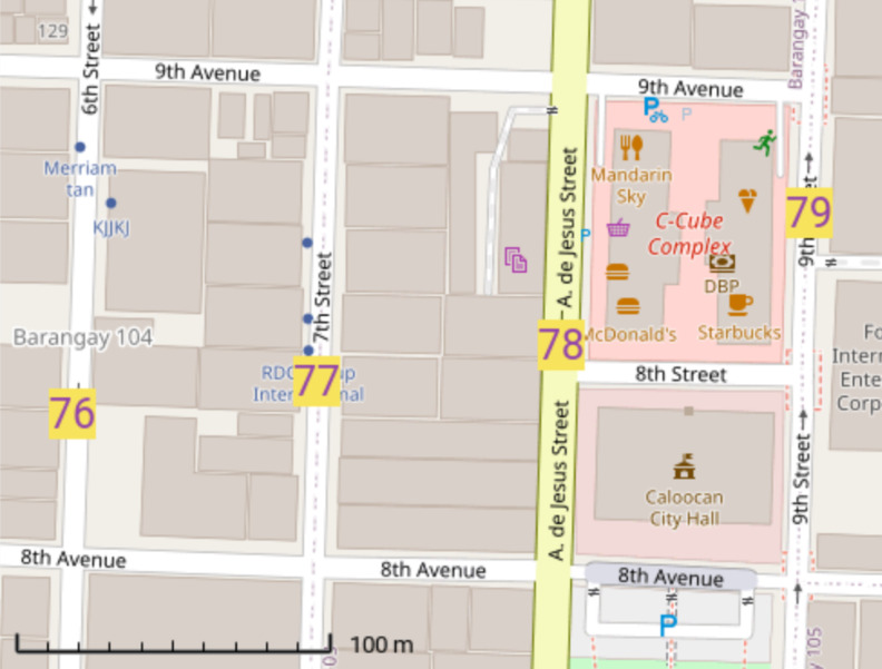
My revision, close up. OSM map. -
Observations
-
Avenues run east-west, and (most) Streets (not all numbers used) north-south.
-
No coordination exists between street names and house numbers. No "700 block starts when you cross 7th St."
-
"Officer needs assistance, corner of 9th Avenue and 7th Street."
Or was that 7th Avenue and 9th Street?
-
-
Recommendations
Unhappy with just looking at maps, we decided to "fix their wagon". In our revision we added 70 to all the north-south Streets names,
Proposed fix:
7 → 77,
A. De Jesus → 78,
9 → 79;
8th St. → 8½th Ave.At this point we no longer need to differentiate street and avenue, and can call them all just Streets, and even just say, "Officer needs assistance, corner of 9th and 79th."
We can still differentiate E/W (< 50), and N/S (> 50) streets, even without the word Avenue.
We can go further, and convert the whole thing to our single axis system. So City Hall would be something like 7850
8½th Ave.Lane 850.
-
-
North Signal Village and Katuparan, Taguig
Speaking about curved areas, boy did they ever blow it:
N. Signal and Katuparan Villages, Taguig. iD editor screenshot. OSM map. Avenue Street 4th 2nd 6th 4th 9th 6th 10th 7th And then there is 8th Street running up the center (name not in image). Alas,
House / street numbering not taught in schools
Even in prestigious universities' urban planning graduate programs, world wide, they simply never get around to teaching smart ways to name or number streets and lots. It's all left to the person who eventually numbers them counting with their 10 fingers. Small chance they know about planning associations' workshops and publications,
-
Pinagsama Phase 2, Taguig
Pinagsama Phase 2, Taguig. OpenTopoMap. OSM map. If I were in charge, that grid would look like
34 44 54 64 53 63 32 42 52 62 31 41 51 61 In other words, pure XY, not affected by gaps.
And how could the name of a street be "Block 16"? "Block" certainly refers to the land adjacent to (one) side of a street. The street name signs there actually read "BLK 16 LOT 20-34"…. Anyway this should have been mapped differently there in OSM.
-
Bonifacio Global City (BGC)
BGC is the only place in the Philippines that finally combines their street name grid and house addressing grid, all in a single grid.
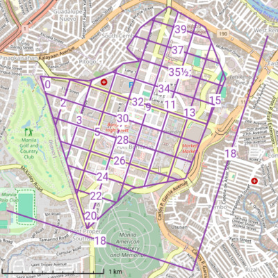
Road number grids observed in Bonifacio Global City (BGC), Taguig. OSM map. 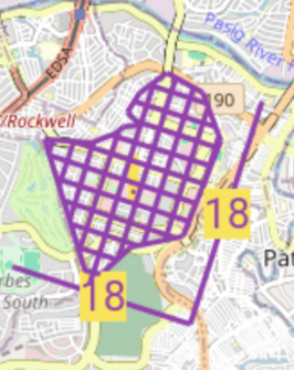
A "virtual 18th Boulevard" shall be our folded single axis. Source code, KMZ, OSM map. (Indeed there are several possible "virtual main boulevards". We could have picked any, 16th, 17th, 18th, 19th, between the highest numbered Avenue and the lowest numbered Street.) "Corner" addresses
Just like in Carmel-by-the-Sea, California, USA, BGC only had "corner" addresses without any house number:
BGC Arts Center

      26th Street corner 9th Avenue
(The OpenStreetMap
addr:address tags are simply:)addr:street26th Streetaddr:street:corner9th AvenueLet's see, such an address refers to both sides of 26th Street, half a block in either direction from 9th Avenue. All in all what would be 850 to 949 26th Street. A total of 100 house numbers! So unless it is some large building you expect to find, you will need to look at 100 different small shops to hopefully find the place you are looking for, just for the ground floor alone. And what about emergency crews (E911)?
Now (2025) house numbers finally start to appear:

932 28th St., near that corner of 28th St. and 9th Ave., September 2025. From this location we also learn even numbers are on the north side of Streets.
The "Cor. 9th Ave" is no longer needed as we know the corner from the "932". ("City Center" must refer to some (naturally) unpublished district, which is not vital addressing here either. )
Signage

BGC street signs, September 2025. OSM map. - 9th Ave ◂ 2611 2815 ▸
- 28th St ◂ 931 730 ▸
Alas, with the well intended small guide numbers on such signs they are setting themselves up for a maintenance headache every time a building is added at a block's end. There is an easier way,
- 9th Ave ◂ 2799 2800 ▸
- 28th St ◂ 900 899 ▸
But wait, even smarter is like the 18th St. sign in this cover,

Zoning Practice 3/2023 cover. 18TH ST 1800 S
Using that system the BGC signs could be just,
- 9th Ave 900
- 28th St 2800
Or Utah style, where the grid value is the name, just,
- 900
- 2800
-
Observations
-
We see Avenues, approximately numbered 1 to 20, running north-south and Streets, 21 to 40, running east-west.
-
One notes the center of the circular street pattern would be at the virtual intersection of 8th Avenue and 29th Street (Bonifacio High Street.)
On older maps there are in fact several concentric circles.
Position Name Current status Outer Rizal Drive mostly intact Middle Federacion Drive mostly gone And two more within them, now gone without a trace.
-
We admit the Ave. vs. St. name difference helps the public with orientation, vs. both being called just Lanes in a pure "single folded axis" abstraction. Especially as 1-20 and 21-40 are bunched together vs. a 75/25 centered system.
-
We notice that north of 35th Street, all the Streets are numbered one less than they should have been. E.g., 36th Street should have been called 37th Street. Sad. (Perhaps they wanted all the "big Streets" to be even numbers, even though their system still permits odd numbers for east-west Streets.) This even forces us, when making our grid overlay, to have the curious "35½" contour line, to deal with the "transition zone".
Also what should have been called 1st Avenue is called 2nd Avenue. Perhaps to avoid dealing with a "0th Avenue" where what is currently named 1st Avenue lies.
They were doing very good at a well-fitting grid until this accident occurred.
Plan ahead
That's what happens when you get too close to the edge. Always plan ahead. I always use 1 to 50, not 1 to 20, with the meridian along 25, not 10. Plenty of room to grow! Still not enough room? Well then use 1 to 500, with meridian along 250. (Yes, 501 to 999 for the other axis. Center on 750.)
By the way, is it 0 to 499, or 1 to 500? I always forget. The point is to have enough room to grow so you are guaranteed never to get even near the two edges, so you don't need to remember.
Don't do like they did in Edmonton, Alberta, Canada. Started out smart at the corner of 100th Street and 100th Avenue, but still overgrew it and had to haul in a quadrant system to ameliorate it. Got to deal with growth below zero one way or another.
-
McKinley Parkway conveniently continues where what might have been called (unlucky?) 13th Street is.
-
We see they use the early part of the alphabet for interstitial Streets, and the latter part for interstitial Avenues, both of which are called Lanes. Hence Lane C is where "9⅔rd Avenue" would have been. But the ordering jumps gaps:
Lane (Avenue) A 5⅔ B 6⅓ C 9⅔ D 10⅓ -
28th Street bends south; 30th Street bends north.
-
Roads are smartly allowed discontinuous segments with the same name. E.g., Lane C, 31st Street, 42th Avenue. After a break all reappear a few blocks later along their same alignment.
-
(If one wants to get picky, one could complain that the letter comes after the word Lane, but the number comes before the words Street and Avenue. (But they are surely just trying to conform to majority English usage.))
-
Any roads at an angle to the grid are smartly differentiated as Drives: 21st Drive. No, one cannot find any ordinances / documentation.
But "Drive" is not used for simple curved road continuation: 5th Avenue.
-
To the northeast there is an area with thirty unrelated numbered avenues. But that is not BGC.
-
Meters per house number
All along in our stories so far we barely ever mention how many meters per house number we were talking about. That's because it doesn't matter. 2 to 5 meters per house number are common.
Examining the map of BGC we note:
-
A big Avenue or Street exactly every 200 meters.
-
The big Avenues have odd numbers; the big Streets have even numbers.
-
We add "00" to 26th Street and 28th Street. In North America that would be how we arrive at 200 house numbers between those two streets.
-
So we would have 200 house numbers per 200 meters, 100 on each side of a road. I.e., 100 ÷ 200 = one house number per two meters.
That's right. On each side of a road BGC uses one house number per two meters. Between 2 and 5 seem reasonable. By the way, one might think rural areas can be different. But what urban area wasn't at one time a rural area? Using the same system allows a block of houses to spring up anywhere and our system is already ready for them.
-
-
-
Recommendations
-
Call grid center 25/75, not 10/30
Too late now, but (afterthought) if I was in charge I would have planned ahead and labeled that same center point as the corner of 25th Avenue and 75th Street, and grow in all four directions from there. For the same two digits, one maximizes the future growth possibilities in all four directions. (But why stop there? That's where four digit lanes come in.)
-
Which sides are odd vs. even
In our photo of 932 28th St. we see BGC has chosen the north side of Streets as the even side. That is joyfully the inner side of my fold.
It's not about north vs. south. In my single axis theory, the inner sides of the "fold" are even, and outer odd. So here the (inner) even would be the north and west sides of roads, and the (outer) odd would be the south and east sides.)
What about Avenues? What did they choose? We don't see any buildings with numbers on them yet to be able to tell. Well whatever they chose it would be too late to change now. Plus it is not some deal breaker or anything.
As BGC intersections often have two sets of signs at diagonal corners, we might be tempted to think we can compare the two to get the answer. However,
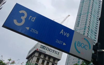
3rd Ave. sign at 26th St., October, 2025. 3rd Ave ◂ 2506 2607 ▸
We see a combination of odd and even can exist on the same sign. (Which in fact was already the case back on that 28th St. sign.)
-
Q: Are number addresses always better than corner addresses?
Again, Taiwan absolutely blew it. They can barely keep both sides of the street coordinated. We're talking about getting off the bus at house number 301 thinking 302 might be across the street, but it's not 302 or 304, but 666! Should have stayed on the bus, until it reached the end and started coming back!
And don't even dream of "parallel streets, parallel numbers". If you want the lockstep numbering needed to make the exercise worthwhile, you had better hire North Americans. But not New Yorkers or San Franciscans. You would think crossing 32nd St. would mean we entered the 3200 block. But unfortunately that's not how it is in those two cities. They blew it.
So now you know why in e.g., Taiwan, besides saying "1313 Nerdsome Lane" one must also mention what corner it is near, if you want the person in the street to find it.
-
Q: Soon we can find everything electronically -
Fine, no need for house numbers anymore. Row upon row of anonymous houses. Streets too.
-
-
-
Links
-
More street name sequences observed at
-
North of Camp Alguinaldo, in Socorro and San Roque Barangays, Quezon City.
-
Around 80 streets whose names start with "Ma", Diliman, Quezon City. (These are merely the same as quietly, gently… streets ending with -ly in English.)
-
Etc. etc. And all over Metro Manila there are groups of streets named using various themes. Jade, Diamond…
Interviews
-
Accu Map 2025/02/12 told me:
There is no central, country-wide planning for house numbers. Also no public database of house numbers. Even within cities or municipalities: except in the city of Manila, that was already built by then. The growth in the past 50 years has been mostly through private communities called Villages or Subdivisions, most of the time gated, the rest being high-rises or squatter areas.
In these private communities, the numbering follows whatever rules the developer chooses, generally blocks and lots, half of the time without street names.
In other, public areas:
-
Every time there is a new municipal election and new Barangay (the lowest elected administrative area) captains, they may choose to re-number houses sequentially, either per-Street or for the whole Barangay.
-
Owners of houses in public areas may not like the new number, or get tired of having the number change; so for a small "fee", they will keep an old number. So there are layers of numberings that are present. Also, with Chinese and Catholic communities, they may skip both "4" and "13".
-
To note: Street names are not unique in a City: there are over 20 "Jade Street"s in Quezon City; this breaks most search functions, including Google Maps, Here, Bing Maps and Apple. The exception is OpenStreetMap which does it correctly (just lacking a few entries).
-
There is no provision for numbering when there is a currently empty lot. So numbering will skip it, never mind what happens when the lot gets built eventually…
In summary, there are pockets of logic, but mostly numbers have to be collected one by one.
-
Conclusions
-
Philippines
Well planned addressing systems stand the test of time with no replacement controversies. Addresses could be part of a two dimensional grid, not just one dimensional number lines.
-
OpenStreetMap
Wouldn't it be great if address grids were part of OSM, just like they are on paper city maps: unobtrusive ticks on the main map. And / or a dedicated overlay just like the bus routes on the Transport Layer.
Possible if a city's grid specification were stored in OSM or Wikidata. (One per city, not one per street.)
-
Role of mapper
We see as mappers we can not only map things, but if we see better ways of doing things we can make our own versions and try to convince the authorities or public that our way is smarter, and if adopted early, save them a lot of pain later.
See also
-
Rebolios et al. (2016) A usability test of four house numbering schemes. (Cebu City.)
Did not consider grids beyond just quadrants.
-
Doesn't keep the right and left sides of e.g., their 5th Avenue in sync. (See their figure 2.)
-
M. Tan (2023) Street Naming and Odonymy in Quezon City
OSM is a great source for the street names they used, but still not that complete yet for the house numbers we used.
-
We find headlines "Marikina enforces house numbering", however an Overpass Turbo query (
nwr["addr:housenumber"~"."]) there simply finds houses numbered from the beginning of streets. That's nice, but there are no grids present, therefore off topic for our article today.
Q & A
Here are some questions we didn't have time to answer at the 2025/10/05 presentation.
- Q: The Philippines has "barangays" as a unique component in our addresses. Can these be considered in the next iteration of numbering buildings?
-
A: It depends. Let's take those
- 123 AYALA AVENUE BEL-AIR
- 123 AYALA AVENUE URDANETA
- 123 AYALA AVENUE SAN LORENZO
again. Works great if those barangays were on separate islands. But as we saw, a 100% disaster in Makati.
Sure, you can always write the barangay,
- 6789 AYALA AVENUE BEL-AIR
but just remember you don't want potholes, administrate boundaries, rivers, etc. to arbitrarily reset your addressing system.
- Q: How does such as grid system work when there are more or less houses than e.g., 100 houses in that grid block between e.g. 100 and 200?
-
Well in Chicago they only use 100-160, except for diagonal streets where they go to 200.
Smarter though is a strict numbers per meter policy. Let's say we are using two numbers per meter. Well, with entrance at 68m you are going to get #34. No worries about future 34A etc. needing to be squeezed in because oops, we "used up all the slack in the number line." (Sure, companies who own the whole block will figure out how to apply for vanity "-00", "6789", etc. addresses.)
- Q: Are block and lot numbers OK for addresses, or must we always use a number + street name?
-
First, it's great if some place already has an address. You don't want to create a second address to avoid never ending confusion.
Think of some Narblestown Highway, which is also Route 34. I never met a local who could remember both names. It's only one or the other.
So block and lot addresses are great too. Just let's hope the blocks are arraigned in a systematic order. I'm talking about something a computer program could create, with no special exceptions for block 67, etc.
Same for the arrangement of lot numbers. As systematic as possible. (Makes me start thinking of Japan and Korea…)
- Q: Can the system be used in other countries?
-
A: Just remember that whatever system you use in whatever country should be something that makes sense to the locals. Something that mom and pop can understand and walk to to without any explanation or cellphone, etc.
E.g., I wrapped this folded single axis system with familiar local address components. What looks on the surface to be a ho-hum usual address is actually packed with guided missile precision components. Well, sort of. I'm sure you could achieve the same.
Of course a dedicated team needs to move in to the numbers bureau to prevent addresses being assigned in former lackadaisical fashion.
- Q: What are your next steps after this grid pattern research?
-
A: I don't know. But I remember my first steps: numbering all the doors in my parents' house's upstairs hallway, which I also named "Jacobson Avenue".